A hike to The Snow Hole: Icebox of the Berkshires
— Photo by Mike Nardacci
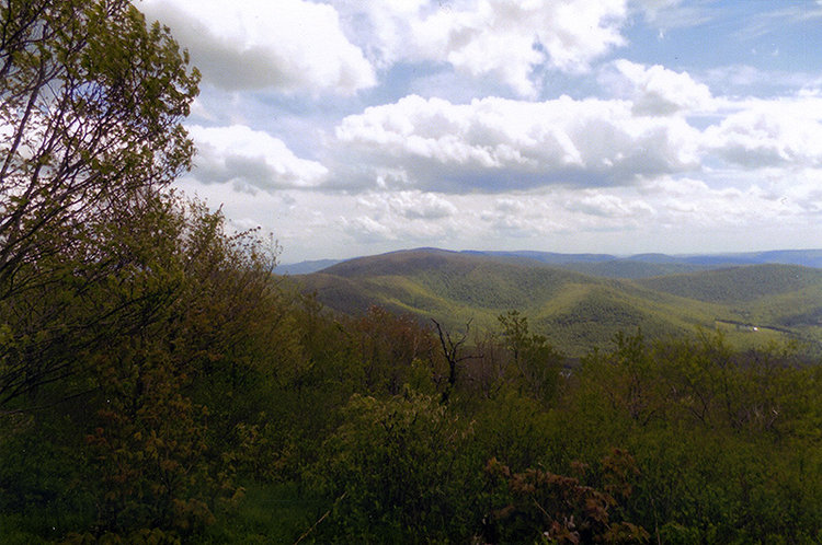
The view south from the trail to The Snow Hole shows Berlin Mountain rising in the center, the highest point in Rensselaer County.
— Photo by Mike Nardacci
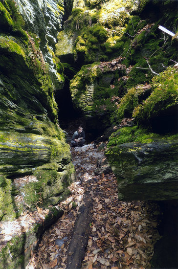
The shady, moss-lined Snow Hole resembles a limestone sink hole. Except during mid-summer, its floor never receives sunlight and traps winter's cold air.

— Photo by Mike Nardacci
Research assistant Devin Delevan holds an ice ball made from snow compressed at the bottom of the fissure.

This archival photo of "Fat Man's Misery" in Thacher Park shows how weathering agents have separated a huge section of the cliff from the bedrock; the force of gravity will someday cause it to crash down to the talus slope beneath it.
To cross the Hudson River and head east on routes 43 or 2 or 7 onto the Rensselaer Plateau is to enter a landscape vastly different both geologically and topographically from that west of the river.
The Mohawk-Hudson lowlands stretching from Albany north to the shores of Lake George are composed of sand deposited on the shore of glacial Lake Albany, which formed over 10,000 years ago at the end of the last ice age and feature low, rolling hills and scattered lakes formed from glacial meltwater.
To the west and south of Albany rises the northernmost section of the Appalachian Plateau — called “the Helderberg Plateau” or simply “the Helderbergs” locally — consisting of mostly flat layers of sedimentary rock: sandstone, shale, and limestone deposited in the late Silurian and Devonian Periods of geologic history. Famous throughout the world to geologists, the layers — or “strata” — contain a vast collection of fossils of ancient species and have been called “the key to the geology of North America.”
The strata that once lay under the sea were elevated by plate tectonic movements during the “Appalachian Orogeny” some 290 million years ago when the land masses that would eventually be known as Europe and North America crashed together in the formation of the super-continent we call Pangaea. East of the river, Ordovician-age rocks took the full force of the collision, and were compressed, folded, and elevated much as the hoods of two colliding cars would be; to the west the Appalachian Plateau was elevated but little deformed — much, say, as the rear parts of the crashing cars might be pushed up above the chassis.
There was a time far earlier — some 475 million years ago — when the east coast of what would eventually become North America was located somewhere near what is today the Hudson Valley. It collided with another land mass consisting of volcanic islands in the great event called the Taconian Orogeny, pushing up mountains that may once have been as high as the Himalaya. Imagine today looking east from Troy and Albany and seeing a range of jagged, snow-capped peaks over 20,000 feet high!
Deep within these mountains, pressures were unimaginable and the rocks there were twisted and distorted and the resultant heat cooked the rocks in the process known as “metamorphism,” forming new minerals and rock types: slate, phyllite, gneiss, and schist, often laced with thick veins of milky quartz. Excellent displays are visible in Petersburg Pass on Route 2 not far from Williamstown.
But the inexorable forces of weathering and erosion — rain, wind, and sculpting glaciers — tore away at the peaks over millions of years. Their remnants in our part of the world — a series of much lower, often steep-sided knobs and ridges — are often called “the Berkshire Hills,” though Berlin Mountain above Petersburg Pass is a very respectable 2,818 feet in elevation, the highest point in Rensselaer County.
Examine the bedrock that is exposed in the pass — or bordering the ski trails on the summit of its neighbor to the south, Jiminy Peak — and you will find twisted and distorted cliffs and ravine walls of heavily fractured phyllite, a metamorphosed form of shale.
Both Jiminy Peak and Berlin Mountain are features of the Taconic Crest Trail, a 37-mile-long hiking path stretching from south to north, weaving in and out of New York, Massachusetts, and Vermont. Extending 60 miles or more on clear days, views from it are often stunning, especially in the fall when the hardwood trees that cover the surrounding slopes put on their spectacular colors.
The hike
From a parking lot on the high point of Route 2 at Petersburg Pass near where the borders of New York, Massachusetts, and Vermont come together, one segment of the Taconic Crest Trail leads south to Berlin Mountain. Another moderately challenging portion of the trail begins on the north side of the highway, leading to the curious feature known as “The Snow Hole”; it can be done as part of a much longer day hike starting farther south or as a 5-mile round trip from the parking lot.
Its ups and downs are for the most part not particularly steep — but as a friend of mine remarked, “It’s just that there are an awful lot of them!” In other words, good hiking shoes and perhaps a walking stick along with water and trail snacks are necessities and, given the often changeable weather, a rain slick is a good idea in warmer months. In winter, the trail is a superb and challenging snowshoe hike, but winds on the Taconic Crest Trail can be fierce and mandate a warm parka.
A steep but short pitch at the start of the trail soon begins to level out and offers an impressive view of the summit of Berlin Mountain and of the eastern and western slopes of Petersburg Pass. Though today the slopes are thickly overgrown with hardwoods, sporadically from 1962 until around 1980 there were trails here for downhill skiing at what was called Petersburg Pass Ski Center.
On clear days, the ski trails of Jiminy Peak and Bousquet may be visible, as well as the rhythmically rising and falling Berkshires to the east and the Helderberg Plateau to the west. A glance at a topographic map of the area shows that the trail runs first along the side of and then on top of a narrow, steep-sided ridge geologists call an arete.
Aretes form in areas previously glaciated when glaciers descend from opposite sides of a mountain, creating the feature that is also sometimes called a “knife edge.” The knife edge on Maine’s Mount Katahdin is undoubtedly the best-known in the east and has long been a heart-pounding challenge for climbers.
But the arete en route to The Snow Hole is far more user-friendly; it is broader and that fact and the thick forests of maple, oak, and paper-birch that cover the slopes bordering this trail prevent any dangerous exposure. There are occasional herd paths that wander from the trail, but the main route is wide and well-marked.
A hard-to-find side path departs from the trail at one point, leading upwards to a feature called “Jim Smith Hill.” This is supposedly named for the “James Smith Club” the main requirement for joining this national social organization is to be named “James Smith” (variant spellings of the names are allowed). Why this bump on the ridge was so named is as obscure as the feature itself.
The trail subsequently passes through a constantly changing variety of meadows and forests with occasional long views to the southern stretch of the Berkshires and west to Albany before reaching a loop trail marked by a sign directing hikers to “The Snow Hole.” After a few hundred feet, the trail begins to descend the north side of the ridge leading to a feature that looks for all the world like one of the sinkholes in the limestone karst areas of Albany or Schoharie counties.
The Snow Hole
The Snow Hole is a vertical fissure in the bedrock lined with mosses and other moisture-loving plants. One end offers a fairly easy descent to the bottom while the other end is a precipitous 60-foot drop. But the fissure is narrow enough and deep enough that its bottom never gets direct sunlight — and that leads to the conditions from which it gets its name.
Well into summer and occasionally into early fall, the bottom of The Snow Hole has a thick deposit of ice formed from pressure exerted by the deep snows that accumulate on the higher summits of the Berkshires during their long winters.
Sinkholes form commonly in carbonate bedrock such as limestone and marble when mildly acidic water from rainfall or runoff percolates through fissures and dissolves the rock, often feeding cave systems below. But The Snow Hole is what is known as a tectonic feature, formed by physical forces.
The steep slope of the ridge contains extensive cracks in its bedrock known as joints that run parallel to the ridge line. Over millennia, water and ice have eroded this fissure and, because it is located on the very steep north slope of the ridge, it has widened and deepened under the pull of gravity. Several much narrower fissures are found between The Snow Hole and the main ridge trail.
Another result of these same processes can be found in Thacher Park at the narrow cleft in the rock known for a century as “Fat Man’s Misery,” which offers access to the trail leading to Hailes Cave though it does not collect lingering snow. A massive section of the limestone has separated from the cliff and gravity has pulled it away sufficiently to allow slender hikers to traverse it. Someday it will tumble from the cliff and crash onto the talus slope below as have many such masses before it.
And this is the fate that ultimately awaits The Snow Hole of Petersburg Pass. Over time, the accumulating snows within it will continue to be compressed into ice, which will further deepen and enlarge the fissure; as the steep hillside is carved away by the agents of erosion the outer wall will collapse and become part of the talus slope that falls away into Vermont.
But there is another fissure between The Snow Hole and the top of the ridge that will also continue to deepen and widen — and some millennia from now it may become the next Snow Hole as the forces of weathering and erosion continue their relentless assault on the ancient bedrock of the Berkshires.