Spider Cave, another piece of the Barton Hill puzzle
— Photo by Mike Nardacci
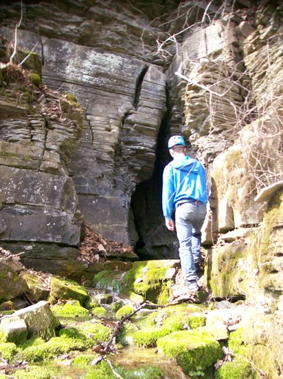
The storybook entrance of Spider Cave, newly acquired by the Northeast Cave Conservancy, beckons research assistant Devin Delevan.
Barton Hill looms above Route 146 as it descends to the village of Gallupville and extends north as a series of impressive limestone cliffs along Route 443 to its intersection with Route 30. From there it stretches to the east with long, gentle slopes and is capped by flat stretches and some of the glacial hills above Routes 7 and I-88.
The name “hill” here is generic, for it is in fact a plateau, an isolated segment of the Appalachian Plateau, cut off millions of years ago from Terrace Mountain (also a plateau), Vroman’s Nose (a mesa), and the Cobleskill Plateau by the respective creeks known as the Fox, the Schoharie, and the Cobleskill.
In addition to the craggy cliffs, its landscape features include broad, fertile farmlands and thick forests — and it also contains numerous karst features: sinkholes, underground streams, and extensive cave systems, not all of which can be entered but which betray their existence through cold springs that burst from the base of the lofty cliffs. Caboose Cave, Schoharie Caverns, Single X cave, and Gage Caverns (historically and again today known as Ball’s Cave) are some of the caves known to geologists and sport cavers, and enormous occluded sinkholes such as the oddly named Joober Hole indicate there are many more.
Until recently, just two of these caves — Gage and Schoharie caverns — have been accessible to sport cavers with the proper credentials because they are owned and managed by the National Speleological Society, an international society devoted to the science and sport of cave exploration. But recently, through a generous donation, another organization known as the Northeast Cave Conservancy has acquired Spider Cave on the south side of Barton Hill, making it available for both student study groups and exploration.
The Northeast Cave Conservancy is a not-for-profit organization that has been managing and acquiring through purchase or donation a number of caves in this part of the country. The NCC has thus been able to keep open a number of caves that might otherwise have been declared off-limits by their owners for fear of liability or for other personal reasons.
For many years, Spider Cave was off-limits to cavers, but the cave with its beautiful entranceway, easily visible from a road, was described in old guide books as having a “storybook entrance but a short story!” To enter the cave, one must first climb a trail up a precarious slope that borders a stream gushing from the entrance.
The stream tumbles over rocks that are rich with Devonian Period fossils and brilliantly green with mosses and algae. The picturesque entrance is a shadowy opening in the Manlius Limestone and it leads to a narrow, twisting passageway that can be traversed on foot through the stream for some distance, though squeamish cavers may find themselves contorting their bodies to avoid disturbing the residents of the eponymously-named cave: dozens (sometimes scores) of large black spiders sequestered in nooks and crannies or openly displaying themselves on the cave walls.
But then the walls of the cave begin to pinch inward, the floor rises, and most visitors turn around as it becomes increasingly difficult to move without having one’s clothing caught and torn by the hard fossils and sharp erosional features on the passage walls. The extent of the cave remains unknown but cavers’ anecdotes tell of intrepid explorers crawling painfully on their sides through pools of icy water, their necessary wetsuits being shredded by the sharp projections from the walls, and turning back after 1,200 feet — or perhaps 1,500 feet — or possibly more, but leaving a small rock cairn to indicate their turnaround point.
Caves with small dimensions can suddenly and without warning open up into caverns of vast proportions — but Spider seems simply to plunge onward into the plateau, guarding well whatever secrets it holds.
The puzzle
And therein lies the puzzle that is Barton Hill. A topographical map featuring the underground passages shows that the known caves run parallel to each other — following what geologists call the “dip” of the rock layers; the “dip” is nothing more than the angle and direction at which rock layers (called “strata”) are tilted.
In this region, the dip of the strata of Barton Hill is gentle and to the southwest. For some of the caves, the insurgences — that is, the points at which water enters the caves from the surface, usually through sinkholes and fissures — is known. For others, the insurgence points have not been identified
This is not unusual, especially in a place like Barton Hill that in many places is covered with layers of glacial deposits, which may obscure features such as sinkholes. But finding the insurgence point for the water in Spider Cave would give an indication of its length, and might provide a way into the cave’s larger sections — if larger sections exist — through a sinkhole or an enlarged fissure.
And particularly odd are the physics and the chemistry of the water emerging from the springs — or “resurgence points” — along the base of the cliffs. During times of normal rainfall, some of the springs above Route 146 may be releasing water — and yet others, sometimes only a couple of hundred feet away — may be dry, though during spring snowmelt or following times of excessively heavy precipitation all of the streams may be gushing. Clearly, something odd is going on underground regarding the flow cycles of the subterranean streams.
Complex questions
The chemistry of these streams also raises complex questions. Cave waters are often saturated with calcium carbonate, and so a cave’s ceilings, walls, and floors may exhibit stalactites, flowstone, stalagmites, and curious dam-like structures in the streambeds themselves called “rimstone pools.”
These form as the water flowing through the cave or entering through cracks in the ceiling “de-gasses” — that is, it loses its carbon dioxide that makes the water acidic and causes the dissolved calcium carbonate to be deposited on ceiling, wall, or floor.
But Barton Hill has some springs known as “tufa” springs: These occur when for some reason the cave water retains its carbon dioxide and calcium carbonate as it flows underground, perhaps in a very small aquifer without any air space, preventing the saturated water from “de-gasing.”
In these situations, as the stream resurges from the cliff base into the open air, the sudden pressure release will cause the water to “de-gas” much as a carbonated beverage de-gases when its bottle cap is removed. Now the dissolved calcium carbonate will be deposited on whatever is in the path of the stream: rocks, twigs, or masses of moss or plant fragments, making the materials appear to be coated with light-colored paint or forming a spongy-appearing rock known as “tufa.”
Calcium carbonate can also form a natural cement and bind together enormous quantities of what geologists call “glacial till,” the mixture of rock fragments and soil left by the retreating glaciers. An extensive area of the hill slope between Gallupville and Shutter’s Corners has been cemented together into a kind of conglomerate by this process; here mineral-saturated water from ancient springs in the cliff far above the slope deposited so much of their dissolved calcium carbonate that they eventually sealed themselves up. This particular outcrop is heavily fractured and appears poised at some point to slump down the hillside onto Route 443.
The stretch of Route 146 approaching Gallupville has several other springs besides Spider Cave, but only one is easily recognizable as a tufa spring and at various times of the year when there is heavy precipitation or snowmelt, the underground stream feeding the spring produces great quantities of tufa that end up tumbling down the stream bed as cobbles or boulders.
Yet, oddly enough, the stream cascading down from Spider Cave also has a mass of algae-and-moss covered tufa in a small area its bed, but not in the stretch above or below it. Clearly, there is something unusual occurring in the chemistry of the stream flowing through Spider Cave that is seasonally altering the acidity of the stream — what chemists call “pH.”
Finding the stream’s insurgence point and examining the terrain under which the water flows on its way through Spider Cave might help to explain its curious behavior.
Numerous studies have been done of the geology and the known caves on Barton Hill; perhaps the best known among cavers and professional geologists is contained in Prof. John Mylroie’s doctoral thesis, “Speleogenesis and Karst Geomorphology of the Helderberg Plateau, Schoharie County, New York,” published in 1977.
But the occluded sinkholes, the shadowy fissures, the numerous bubbling springs, and the still-unexplored stretches of caves both known and unknown tell us that the beautiful forested plateau yet holds many secrets.